YOLO folks in Nevada. Fair warning: There are LOTS of rock photos included in this post.
Here is Karen on the shore of Lake Tahoe. This doesn't count as a rock photo.
Our first stop in Nevada was Carson City, just across the border from CA. The silver-plated capitol building dome represents the silver that made this state rich and famous back in the 1870's. We spent some time in a self-guided tour through the capitol.
Snow at the top of the pass from CA into NV. Winter hasn't given up at the higher elevations.
Jason at a scenic overlook as we crossed from CA to NV.
Still looks like a winter wonderland up in the hills.
A lake is starting to show signs of snowmelt nearer the bottom of the mountain.
Ski areas in the distance still have the slopes covered.
The lake is still mostly frozen, with a few cracks starting to show open water.
The snow balls roll down the hill. This could be the evidence of a mini avalanche recently, too.
A mural at night as we passed through a fast food drive. Strange colors with the lighting at night.
A statue of Winnemucca, the first Native American published author. She stands in the foyer of the capitol building.
This huge safe is where the gold, silver, and cash used to be held. They had to close it off when they built fire stairs for safety behind it years ago. It is quite ornate for such a heavy safe door. It's now in the Sec'y of State's office and I was surprised they let me go in her office and open this safe.
Our first sighting of Lake Tahoe.
From the NE corner of the lake, looking back at the mountain range that is in CA.
Tahoe is a pretty lake surrounded by mountains. It's half in CA and half in NV. We only ventured along the NV side.
The clear turquoise water of Lake Tahoe is what draws people here. I love looking
through the water to see the bottom of the lake.
Karen at Lake Tahoe.
Jason testing the water temperature in Lake Tahoe. He said it wasn't as cold as he would've thought. The water clarity is a draw for tourists.
Looking back at Lake Tahoe as we cross back over the pass to get back to Carson City, NV.
Snow-capped mountains seemed to still be evident in lots of places this time of year. These are the Sierra Nevada range.
The dry slopes of the mining hills around town are a stark contrast.
Looking north from a hill above Virginia City, towards Reno, 30 miles away.
Some old stone ruins on the hillside above Virginia City.
"Thar's gold in them thar hills". An old ore cart used to carry the ore from the mines.
James Fair, one of the five 'Bonanza Kings' who ran the Comstock Lode. Our friend in Mt. View, CA is a descendent of this guy and actually bears some resemblance.
Jason waiting outside the 'The Way It Was Museum' in Virginia City. It was filled with photos and artifacts of the mining heydays in the late 1870's.
A sculpture of a miner panning for gold in front of the museum.
Jason waiting for me to come out of a rock shop in Virginia City. He knows I'll be a while.
An old coot dressed as a miner from the 1870's, complete with a tricked out burro to carry his equipment. He looked pretty authentic.
The famous Bucket of Blood Saloon.
A trolley carries tourists up and down the street in Virginia City. It is a hill with a bit of a grade to it, at a high altitude, and there is little parking in town, so the trolley will be necessary as the tourist season ramps up.
This monument to the Comstock Lode that made this city famous is made up of rocks that represent the different ores and minerals that can be found in this county.
Looking down Main St. in Virginia City, NV.
The town's facade is authentic from 1875-1876, The town had a fire in 1875 that wiped out most of the wooden buildings, but the boom going on at the time paid to rebuild most of the buildings that are still standing today. A true western mining town that now caters to tourists.
Some of the decorations are unique to this area. Note the real wooden boardwalk that goes back to the 1870's, too.
I can relate.....
These old fashioned sugar sticks were just one of the many oldtime treats available in the sweet shop. I had to hurry out of there before the temptations got to me.
Really?
This entire side of the building is just painted on. Those windows aren't really there.
I liked this town and some of its funky decorations and storefront window displays.
You can see the bark peeling off of the log on the front of this store front.
The Way It Was Museum. There were lots of billboards along the road to advertise the place and it seemed to be the best museum of the area. It was small, but chock full of stuff.
This is the Chollar Mansion that belonged to one of the five Bonanza Kings back in the 1870's. It was built in 1861-1863 and is reputed to be haunted. It's a B&B now.
Once the richest place on earth, according to this sign.
This Fourth Ward School is now an historic museum of local life and education in the 19th century. Its exhibits include Mark Twain's life here and the mining history of the area. Buildings back then were rarely this tall.
This wooden coach stood along the road as we drove from Virginia City over Gold Hill to Silver City.
If you look close you can see the wild mustangs on the ridge in the left of the pic.
More wild horses were across the highway in this field.
A metal statue near Carson City that represents the Pony Express riders.
More metal artwork showing a pioneer's conestoga wagon pulled by oxen.
Can you see the desert horned toad here?
And here? We stopped to hunt for agates and I almost stepped on this little guy.
Jason walking the trail to see the Grimes Point petroglyphs.
The designs are carved or knocked into the rock, not painted on.
Some are nearly indistinguishable after years in the desert environs.
The holes apparently have a meaning, too, but we don't know the story behind these markings.
The designs are 500-2500 years old on these rocks.
Some think the shamans may have used this area for sacred ceremonies.
They are all a bit different.
Wouldn't you love to know the story and meaning behind these?
Is this a hand or a tree?
Lots of holes here.
Some figures are pretty intricate.
Some are simple and recognizable, like this spiral.
We think this is a buttlerfly.
Some of the rock is chipping off, taking the ancient markings with it.
An 8-pointed star.
This entire rock is cracking.
This rounded, flat rock seems to have a well in the middle that is filled with sand and rock, but no carvings.
A sign as you pull in gives what info is known about the site.
More carvings on a broken rock.
Some still look pretty clear.
Several big rocks had petroglyphs on several sides.
This rock has divots in it on several planes.
These little carved holes meant something special. Or they may have held potions.
More intricate designs.
The area of the petroglyphs is pretty nondescript. This is looking out from the site.
This rock just had pretty lichen on it. The splash of bright color made it noticeable.
The road along the salt flat was pretty desolate.
In the distance, you can see the white sand dune up against the mountain.
We turned in to see what the sand dune park was like. Just sand with lots of rock circles for fires when campers come here.
The dunes themselves are covered in tracks from vehicles being driven up their faces.
It's a pretty barren looking place to camp, but the RVs and ATVs must love it.
Outside of Austin, we encounted this old cottonwood tree covered in shoes.
This shoe tree out in the desert had quite a variety of footwear hanging in its branches.
Looking the other way from the shoe tree, you see a dry desert gully.
We were traversing the area where the Pony Express was famous. There are some old remains of the Pony Express stations along the way. This is the remains of the first telegraph office that put the Pony Express out of business.
The ruins of the rock buildings are now being protected and cannot be accessed directly.
You can look through a fence at the remains.
Just a pulloff along the road with fenced-in rock structures that are no longer used.
This lavender field sprawled up against the mountains. I think it was clover.
A sign at a site of the remains of a pony express station.

Quite the backdrop for the Pony Express rider.
We were surrounded on all sides by mountain ranges in Nevada. I'm impressed that any pioneers ever got across this land.
We passed a sign about the Hickison Petroglyphs (another one of those roadside surprise places we'd never hear about) and turned onto the gravel/dirt road. Odd rocks started to show up.
The petroglyphs here are carved into softer sandstone cliffs.
There is still no definite known interpretation of these markings.
Someone thinks this site was meant mostly for women.
Lots of little caves and overhangs in the rocky outcrops.
Again, the holes have some meaning.
The pink sandstone slabs that once formed a cap have fallen onto the side of the hill.
Some rocks have holes eroded through them.
Lots of strange pockmarks are probably just Mother Nature eroding the elements at different rates.
This rock is easy to carve into.
Jason looking at a pockmarked rock.
What's natural and what's manmade???
The pink hoodoos look cool.
A cave of some significance.
This petroglyph is way down low on the rock.
A mix of manmade marks or carvings and natural erosion.
This rock outcrop has petroglyphs on all sides.
Long lines form this carving.
More mysterious markings in the pink rock.
This one looks pretty complex.
Caves, gullies, petroglyphs....this rock has it all.
This special rock has been fenced off to protect it.
The pink cliffs look interesting, even if they didn't contain petroglyphs.
You can see our reflection in the sign at the start of the Hickison Petroglyph hike.
Those black things on the left are HUGE tires, as tall as the garage doors on this facility.
This entire town in NV is a huge mine tailing.
Eureka, NV still has some old west style storefronts along the main street.
This red brick building has been very well maintained as the library.
We stopped at Garnet Hill to prospect for garnets. Luckily, the road grader had just smoothed the ruts into a drivable road again so we could make it to the top of the hill.

Jason breaking rocks to get the small garnets out of the rhyolite. We finally put my rock hammer to good use. We could keep any we found and ended up with about a dozen gems in an hour or so.
The mine tailings across the highway were an amazing quilt of colors.
Each different color is a different dump truck of discarded material from this mine. They focus on copper mostly, but gold and silver and some other stuff is kept, too. In sunlight, the colors were stunning, especially considering their source.
You can hardly imagine the scale of this mountain of tailings just outside of Ely, NV.
An old paint advertisement on the side of a building i n Ely.
Old buildings have been preserved, along with their typical contents on a block in Ely. Renaissance Village provides a glimpse into the past for this area. This is the General Store.
You can wander around the cluster of stores and homes. They had a typical home for each of the immigrant types that worked the mines: Italian, Greek, Mexican, Chinese...
This caterpillar was created from the hedge out front. Cute.
An old coal and wood bin out behind the general store.
The railroad runs along the back and above Renaissance Village. This is looking down the stairs at the old buildings.
This iconic miner adorns the corner of an historic hotel on Main Street in Ely.
The other side of the hotel sports this painted mural.
There is a walking tour of the painted murals on the buildings in Ely. This one represents the charcoal furnaces that were in the nearby hills to create charcoal for smelting processes.
Jason in front of a mural on the local telephone building.
The light and white of this tree against the bright blue sky caught Jason's eye.
This mural represents the local caves in the area, but seemed a bit spooky to me.
A home scene from the mining era.
The man wrapped only in a towel, bathing, seemed a bit forward for the times, considering the Victorian dress of the folks in the other half of the mural.
The local countryside that the Pony Express would've ridden through.
Scattered, bleached bones in a field along the road where we stopped to look at the rocks.
A skull like this would've made an interesting decoration. I understand some folks pay nicely for these for decorative pieces.
A sign about the aerial tramway used to transport ore in Pioche.
The old tram station. There were still cars on the cables.
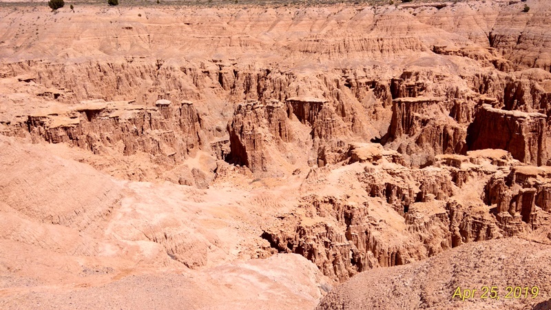
Just before we left Nevada, we turned south and ran into the Cathedral Gorge. We pulled in to have lunch and a look.
A hoodoo canyon in the making.
The soft Navaho sandstone erodes quickly to form these interesting gullies and pinnacles. Selfies aren't my forte.
The intricate patterns of valleys and gullies changes over time.
Jason reading next to the gulch.
The stairway down to the valley floor. We didn't go down to the valley floor to explore.
Different shades of pink are all the highlight, too.
The roof of the viewing platform was interesting in itself.
Funny how it just suddenly starts somewhere and erodes away from there.
This would be an interesting valley to explore. It reminds me of making sand castles with handfuls of wet sand dripping through my fist.
The view we saw when we drove in to munch on our Subway sandwiches.
Pinncles in pink sandstone.
That tiny person way out there is Jason, who climbed down the first flight of stairs to get out to the overlook point.
Looking back towards the road.
Jason coming back. We still had a long drive.
A little closer look.
Can't get too close to the edge here, as it is soft,crumbly footing.
A view from the start of the valley.
Another view of the valley with different lighting. The angle of the sun makes so much difference in the colors here.
Here, the rain hasn't eroded the hillside into gullies yet.
The harder the rock, the longer it withstands the ravages of Mother Nature. The hard bits become the tops of the pillars.
Jason admiring the view at Cathedral Gorge in southern Nevada.
A delicate purple flower lends another hue to the grounds here.