YOLO folks in Utah, April 2019

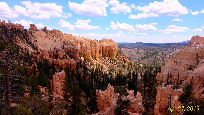
This blog could also be called Karen's Rock Fantasy. The visits to Zion and Bryce Canyon National Parks should really be two separate blogs, but I loaded all the photos to one, so this is really long. Deal with it. Both places were fabulous! Above is one of my favorite views of the hoodoos in Bryce Canyon.
A spring hailstorm greeted us as we entered Utah and if you look closely between the two right railroad crossing arms, you can see a funnel cloud that dipped down from the storm cell. Welcome to Utah.
A lovely, lively, colorful quilt draped over a chair in the visitor's center in Cedar City, UT. We waited out the rain inside and I gathered rockhounding info from a book in the gift shop.
Morning red rock cliffs before we got any sunlight on them. We had an hour's drive to Bryce from our hotel in Cedar City, so we had to get an early start.

The shuttle bus in Zion Canyon for tourists. You can't drive your own vehicle in the park during the tourist season April-October. We took it all the way to the end and then got off at each stop on the way back.
Jason and Karen on the bus to one of the lookout spots.
The cliffs and rocks seemed to change color with the light, fron light yellow to dark red.
Massive walls of pretty red rock.
Rain dripping over the millenia have created stripes on this overhang.
Waiting at a bus shuttle stop to go to the next lookout spot.
I like the dark stripes on the dark red rock.
Colorful cliffs along the shuttle route in Zion.
Zion view.
Another view of a striated overhang in Zion.
A close up of an overhang across the river.
Pock marks in the walls of the canyons.
The sun-baked rock on the tops looks blackened.
The river flowing through Zion. High water from spring rains had washed out some parts of the road and paths.
Jason at the end of one of the paths along the river.
People stack stones into fanciful carins or towers along the paths.
More stripes from the minerals dissolving in the rain and dripping over the rocks.
Where the water has repeatedly dripped, we can see holes in the rock.
The trails were no longer closed due to ice, as the sign indicated, but the path ended soon thereafter.
Sun and light differences make the colors look different.
A small waterfall in the park.
A majestic spire of rock.
A few purple flowers had begun to show themselves along the paths.
The jet contrail looks tiny above this tall wall of rock. Gives you a little perspective.
This slab of red rock looks like an arrowhead ready to fall.
You can see its placement in the cliff of rock below.
I'm sure rock climbers must love this kind of rock face.
The river winds through the canyons cut deep in the rock.
This looks like a glacial bowl to me.
A stairway down to the water in Zion.
Wouldn't want to have to climb over these hills of rock.
This woolly caterpillar was crawling along a pathway in Zion.
The lighter colored rock is a different mineral at the top.
You can see what a beautiful day we had for the viewing.
The stripes and caves on this face look interesting.
A close-up of part of the cliff above to highlight the caves.
Sheer rock faces on a grand scale.
Jason passes under a twisted old tree trunk over a path along the river.
I'm in rock heaven in this kind of country.
Another view of the same rock structures from a slightly different angle.
This is actually a reflection of the mountains of rock above us on the other side of the river. A small pond was perfectly still and created the mirror for this picture.
You can see where the color changes in the different layers of rock. The more iron in the rock, the redder it is.
A scenic view of a distant rock wall
Can you imagine seeing this for the first time?
A few wild turkeys strutted around on the path along the river.
Twin Sisters of hard rock.
A few desert flowers put a splash of color in the roadside shrubbery.
You can see the undulations of the rock layers.
Imagine the pressure it takes to bend rock like this.
More red flowers in the dry sand.
These look like firecrackers.
Red seemed to be the dominant flower color so far.
Jason avoiding a spiky cactus plant.
Kayakers were in the river, even though they weren't supposed to be there.
The buildings blend in with the scenery well.
The stripes from different layers of rock are evident from afar.
The reds fade to oranges as we move along. We headed to the other part of the park, Kolob Canyon.
A majestic view of the mountains in the distance,
The barren lava rock here has just a thin coating of greenery.
A nice depiction of the pinkish red of the mountains in Zion and Kolob Canyons.
Same rocks, different colors in different light.
You can almost get an idea of the grandeur and scale as we look off into the distance.
The view from the walkway in Kolob Canyon.
A close-up of the cave forming from the center of the photo above.
The path we followed up to a lookout. No pavement here.
Jason using our little binoculars to look off into the distance from the lookout on the top of a mountain in Kolob Canyon.
Part of the pathway had log edges to keept he dirt in place.
A van from California had climbing knobs on it and Jason just couldn't resist them.
A valley view like this belongs on a brochure.
The purple clover in the distant field created a mirage of color as we left Zion.
Lavender fields nestled up against the rocky mountains.
Metal cutouts of a miner leading his line of mules appeared in the field along the road.
Sunset storm from our hotel room in Cedar City, Utah.
Entering the Dixie National Forest on the way to Bryce Canyon. Already the rock formations and hoodoos start to show themselves.
How can you not love these spires in nature?
It's hard to believe these tops haven't toppled over the years.
We drove through this arch on our way to Bryce Canyon.
And this one, too!
Our first glimpse of the valley of hoodoos....awesome!
Looking down the side of a mountain to the fanciful columns of sandstone below. Actually, the rock in the Claron Formation (a geological formation that encompasses Bryce Canyon) is a mixture of limestone, sandstone, siltstone, mudstone, and dolomite. Each rock type erodes at a different pace, so the softer rock below eroded away faster, leaving the caps and the spires you see here as hoodoos.
The scenery goes on forever.
Yellow and orange predominate in this early morning. Note the patch of snow still on the slope.
The dark pink of the sandstone gets washed out in the sunlight here.
Bryce Canyon is pretty deep. We didn't go down into the floor of the valley.
You can tell it's a long way down into the canyon.
And a long way back up! Elevations range from 4500-11,000 feet, so that could be over a mile in elevation difference.
That one in the center looks ready to tumble any time now.
What a wild world of rock here! I love these hoodoos!
Each one is unique, too.
Around a curve, a different view and the light makes them look a bit different.
Karen selfie in front of the snowy hoodoos in Bryce Canyon.
Looking down the side of a hill of hoodoos.
They are quite colorful in their odd forms.
Another selfie on an overlook. There are 20 or so overlooks you can drive your vehicle to and get out to walk to the edge of the canyon.
I really like the reddish orange of these towers.
You can see the 'Hole in the Wall' near the center of the photo.
Another view of the valley of the hoodoos. They remind me of sand sculptures you make by letting wet sand drip out of your hand at the beach.
A grand scenic view.
Jason scoping out some scenery.
Evidence of a recent forest fire that swept through here. There are 13 miles of roadway along the rim out to the end of the overlooks. This was along the high road.
The hoodoos in this selfie are more light colored.
The snow on the mountainside makes a nice contrast to the orange rocks.
The rim along the canyon road is 8-9000 feet high, so the altitude helps keep the snow in the shade here.
This is Thor's Hammer, a spectacular example of a hoodoo formation.
This arch, called 'Natural Bridge Rock' is amazing in its formation. Rain dissolved the chemicals inside the hole, but left the harder rock on top and around the sides intact.
It's like looking through a giant keyhole to the valley below. The hard red sedimentary rock of the Claron Formation is the mainstay of the rocks here. Softer rock types below the top layer were washed away by water, leaving the hard caps to create these features.
A pathetic selfie with the arch in the background, from the rim of Bryce Canyon.
Looks like someone just set a rock on this giant pedestal.
Looking through the natural arch to the valley floor below. It's a long way down!
You can see mountains waaaayyy off in the distance.
Another natural bridge in Bryce Canyon.
A valley view from the rim of Bryce Canyon. You can see how the light makes the colors differ as a cloud shadow passes over part of the view.
Beyond Bryce, the hoodoos are still in the formative stages as we drive along the road
The hard caps keep the columns from eroding evenly and create these oddities of nature.
These tall pillars of rock are imposing and impressive.
Outside the park, the formations aren't as defined, but they are still impressive as we drive along the road.
Castles of red rock in Utah.
At the higher elevations, the water was still frozen and covered with snow.
We drove over the pass and had to traverse 10-11,000 foot roads to get back to our hotel. Cedar Breaks and Brian Head are two areas we missed. The road to get to them was still closed due to snow.
Still a snowy landscape up on top, but Jason in his shirt sleeves didn't seem to mind.
The lack of iron in this rock keeps it from being the showy red of the canyons.
The river runs pink from the runoff of the red rocks.
You can see where the mineral content changes; the red is rich in iron, whereas the white is not.
An interesting wall of rock as we drove through Utah.
Another shoe tree along a river road near Bryce Canyon.
Jason cleaning the sand out of his shoes after walking along the nearby river.
A spillway of pinkish orange river water coming out of the park.
Massive slabs of orange rock along the road were our lunch stop scenery.
Alternating red and white stripes with the blue and white sky; how patriotic.
A restful looking valley.
When the red color is missing, the rock looks harsh and formidable.
Looking across this vista, you'd never suspect a canyon like Bryce was just over the edge.
A couple of roadside pulloffs for scenic overviews allowed us to walk to the edge of other canyons. A step too far and you'd be over the cliff before you knew it. You'd never know these dropoffs existed if you didn't pull off the road for the signs.
One of the clifftop pullover views.
And a dash of purple just for color.
A typical mesa along the road in Utah. Like Castle Rock in Colorado. Eventually, this could become a hoodoo, but not in our lifetimes.
Different layers create the striped rock formations that make up the mountains here.
Different colored layers are easily seen where the roads have cut through the mountains.
Ghost Rocks, whitish formations that stand out along the road. Pioneers and/or Native Americans first saw these rocks as they loomed out of the fog at them; hence, their name.
We stopped for a snack here and marveled at all the little cubby holes in the rocks, some big enough to be called caves.
Another view of Ghost Rocks across the highway.
This view looks like we're heading into the prow of a big pink rock ship.
From here on, the vistas were still fabulous, but just too much for the little phone camera to capture properly. We headed from Utah into Colorado and headed back towards the family. Utah is a spectacularly scenic state and should be on anyone's list for trips through the southwest of the USA.