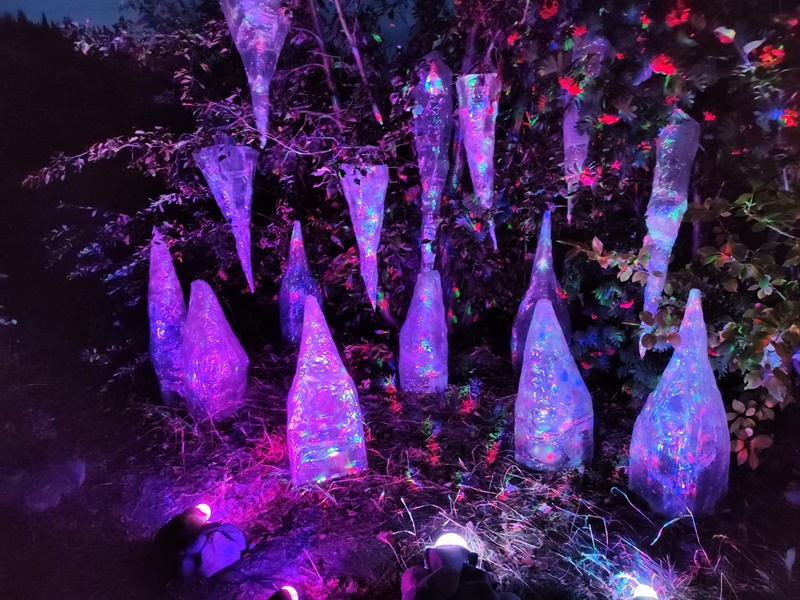
Before leaving Whitehorse, we took in the nighttime event of Wonderhorse, a showcase for emerging art. These crinkly crepe-paper icicles lit by colored lights was one of the first displays we encountered on our walk along the riverside pathway.
This shadow puppet stage was at the other end of the walkway, several blocks away. It was a very windy night and just holding a shadow puppet took two people, but we passed on the opportunity.
No photos are allowed inside the Nordic Eclipse Hot Springs Resort, shown here. We enjoyed the hot pools, but the procedures in this place seemed ridiculous to us.
A local Yukon beer, Kokanee.
Emerald Lake, aka Rainbow along the South Klondike Hwy. as we headed towards Skagway. The marl bottom (white sand and shell mix) makes the shallower parts of the lake take on every shade of blue and green as the sunlight shines through it. A very pretty body of water, especially when viewed from above, it is said to be the most photographed lake in the Yukon.
Jason peering into the clear waters along the shore of Emerald Lake, near where we parked for the night.
Karen with a backdrop of the golden aspen and Spirit Lake.
Our parking spot for a night, you can see YOLO on the left. Emerald Lake is just beyond the view.
Carcross boasts "The World's Smallest Desert". Sand from an ancient glacial seabed here and grit ground by nearby glaciers gets blown by the winds and has created huge dunes that are trapped here along the mountains.
Jason pointing towards the top of the dune we were to climb.
Sand art at the top of the dune, with the brilliant gold aspen and birch. Autumn colors are showing here in early September.
Looking the other way from the top of the dune, we see the blue of Lake Bennet at Carcross.
Karen on top of the big dune at Carcross Desert. It was a tougher climb than it looked from the bottom.
Jason jumping/running down another side dune.
Carcross used to be called Caribou Crossing because huge herds of caribou migrate through the area and crossed the rivers here. Now a tourist stop/RV Park, it was unexplainably closed the day we went. We turned back to go here after the desert as a billboard along the highway advertised husky puppies to cuddle. Didn't happen for us.
The local cultural center for the First Nations people is new as of 2015 and is just outside of town. The famous carver, Keith Wolf Smarch, carved the six big totems outside, one for each clan, and several other items inside the center.
This driftwood woman welcomed visitors just inside the door of the cultural center.
The male counterpart of driftwood across the front room. Lots of trees and wood get carried down the rivers and get polished by the rocks and sands as they move down the waters.
The local Tagish First Nations tribe was practicing a ceremonial dance to be filmed for national broadcast later that day. What a beautiful backdrop to the ornate costumes.
The pointed woven hats are traditional Tagish design.
More Tagish men in costume for the ceremony. I was asked not to take any more pics or movies as they were afraid I'd post them prior to their broadcast that day.
A tribal canoe and carved housefront in another large room in the cultural center. You can see the mountains and golden aspen outside, too.
A few of the trees even sported a bit of red in their leaves, not common in the trees here.
The burned remains of the paddle wheel of the sternwheeler boat, Tutshi in Carcross.
The bow of Tutshi, the decks and housing burned during its restoration a few years ago. The burn halted its restoration as the owners couldn't afford to start again, so it sits in its current charred condition in Carcross.
Karen in the tiny locomotive, Duchess. It was used to shuttle supplies to the main rail cars along the river and between the lakes here.
Someof the original buildings in Carcross have been, or are being restored to their 1898-1900 conditions. Carcross was the meeting of the Alaska Railroad between Whitehorse and Skagway, where its 'golden spike' was driven.
The original train depot for the White Pass & Yukon Route railroad in Carcross.
A wooden dock, buckled by the ice on the river I presume.
An old wooden structure along the river in Carcross. The river joins several large lakes, Nares and Bennet Lakes, here. The water color, that clear aqua green, is typical of glacial-fed waters.
An old Ford truck next to the the restored hotel in Carcross.
The old Chilkoot Trail sourdough bakery building, now apparently abandoned. Lots of old tin washtubs outside.
We hiked along the shore of the lake and back to town along the ATV trails.
Fireweed going to seed along the rail tracks leading back into Carcross from our hike.
Jason looking in the window of a funky little rail car on the old tracks. We think it might be used for railway maintenance.
A barefoot Jason sitting outside of YOLO in the Visitor Center lot at Carcross after our hike.
The cool metal carvings of the bike rack at the visitor center in Carcross.
Historic mile markers like this one are seen along some of the historic highways in Alaska. This one indicates we are still 66 miles from Skagway, here in Carcross.
We woke in the morning to a low blanket of fog, with the sun trying to burn it off and the wind trying to blow it away. It didn't take long to clear and it was another sunny, fine day in Carcross.
The sign on this local house outbuilding says 'Retirement Home'.
The view down the Nares Lake on a calm morning.
Just swivel left from the previous view and you get the local shoreline here at Carcross. Lots of bike trails originate here and cover these hillsides.
The old railway bridge that crosses the river between the two lakes at Carcross. The White Pass &Yukon Route train no longer runs here, but there are signs stating it is still an active rail bridge and not to walk on it. Only the work train uses it once in a while, so lots of people ignore the signs and walk across it rather than step the farther distance to cross on the pedestrian bridge from where this photo was taken.
The water below the bridge is a clear green, with lots of lake trout visible hovering above the sand or staying still behind some stone.
A view of the pedestrian bridge at Carcross, taken from the end of the old WP&YR railroad truss bridge.
Bove Island is in the middle of a lake of the Windy Arm of the Tagish River as we headed south out of Carcross. It was considered a menace to navigation by the big boats that plied these waters years ago. A huge granite pluton and gold aspen make it a scenic view these days.
We stopped near the Conrad Crek Campground and parked along the rocky creekbed for the night, listening to the burbling waters.
We had a fire to use up some of the firewood and roasted potatoes and hotdogs for dinner.
The local First Nations are trying to restore some of the buildings used by their ancestors when hunting and gathering in the area. This one is barely being held up.
The pretty gold aspen and birch remind us of Colorado colors, even though they've had such a dry summer that they aren't seeing colors this year.
More pretty tree color along our drive. Would've been more spectacular if the sun was out..... We sat along the side of the road for a bit, hoping those spaces of blue sky would allow the sun to shine on these trees, but we finally had to give upa nd move on.
Some of the scenery was more barren, with no big trees near us. The white of the distant mountains may be white volcanic ash from old volcanos or sand as is seen in the foreground.
This rounded granite landscape was ground off by the glaciers, leaving a rocky, lumpy ground for the trees to try to find purchase in.
The rocky landscape on one side of the river,with the railroad tracks directly below the trees on this side. Not much room for the railroad between the road and the water.
The White Pass & Yukon Route tourist train leaving Skagway for a run to the top of the pass. Trains run all day every day for tourists in Skagway.
As soon as they climb out of the valley from Skagway, they often hit the clouds, like these we encountered on our way into town. Don't see much of the reportedly stunning scenery from the train in this weather.
As we crossed the summit of the pass and headed down towards Skagway, we had to pass through US Customs and Border Patrol once again. We could barely see their building in the rain and fog on the mountain.
A statue of men heading over the Chilkoot Trail, a route used by gold rush miners to get over the mountains and up to Whitehorse to carry on to the gold fields near Dawson City. The Royal Mounted Canadian Police demanded that each man carry 2000 lbs. of food and supplies to survive the harsh winter. Some men hired local natives to help carry their goods up and over the pass. It took dozens of trips over the treacherous ice trail to convey their ton of stuff.
Once the railroad made it from Skagway to Whitehorse, it was still a chore to keep the rails clear of snow in the winters. This special-made snowthrowing engine led the locomotives and a huge engine powering this snowblower could chew through 12-foot drifts of snow and keep going. Amazing!
A log cabin from one of the original founders of the town is now part of the HIstoric Gold Rush National Park that encompasses most of Skagway. They own many of the buildings in town and have restored them to their 1898 condition to give visitors as good a view of the lifestyle and buildings from that era as you can get.
The Back Alley Rock Shop had so many cool rocks and minerals in it I didn't want to leave. This colorful chunk of petrified wood is just one of the many treasures it held.
One of the storefronts in Skagway sports my maiden name so I had to take a picture. Lessees of the stores are required to keep the old-timey look and feel of the historic buildings.
This unique driftwood exterior of the Arctic Brotherhood really stands out in Skagway.
A look down the main drag, State Street in Skagway. The dark cora-colored buiding on the right is the National Park visitor center.
A one-lane bridge Jason was reluctant to cross on our day trip to Dyea. We met the limits for axle weight, but the boards looked a bit sketchy.
Looking up the flats in the valley from Dyea towards where the start of the Chilkoot Trail headed up and over the Coast Mountains. This town was where miners packed their goods for the long arduous climb over ice steps at the end of the 33-mile trek over the mountains. In fact, the word Dyea means "to pack goods" in the local native Taglish language.
One of the braids of the river as it feeds into the Lynn Canal, the longest and deepest fiord at the end of the river here in Dyea.
Jason viewing the flats on our tour around the Dyea area on a drizzly day.
The valley leading to the Chilkoot Trail was once filled with people, tents, and tons of goods that needed to be carted over the mountains in the distance.
There are almost no buildings left of the town of Dyea, but we found heaps of huge mushrooms in the area. These bright red, polka-dotted amanitas aren't edible, but they sure are pretty.
More amanitas of the yellow variety, still huge.
When they open up flat, they are even bigger. This one was bigger than my foot!
Jason examining some of the mushrooms in a big field of them in Dyea.
On April 3, 1903, an avalance killed over 60 of the miners climbing the ice steps on the Chilkoot Trail to cart their goods over the mountains. Natives had warned of the avalanche conditions, but stubborn miners went on anyway. The dead were buried in the cemetery in Dyea, their starting point. These old headstones are all that remain of the town.
This grave had its own picket fence around it.
Wooden headstones were set up for the graves when the cemetery was relocated in 1979. This man was shot in the mountains on May 1st, 1898.
He was buried right alongside many of the avalanche victims like this one. Many of the wooden headstones didn't have so much info on them.
A view of the area where the river meets the ocean at Dyea.
Jason looking down over Skagway on the road to Dyea.
The cruise ship dock in Skagway from the road to Dyea.
Jason waiting for our halibut fish and chips at the Bonanza Bar and Grill in Skagway. It didn't compare to the ones we had in Homer.
I liked these colorful woven cloth hiking boots in a shop called The Loom in Skagway. Note the price tags say $289 for a pair, but everything was half off (the perpetual sale for cruise customers). They did have some nice hide rugs here, but the pricing is idiotically high.
A sculpture of an old musher and his pack dog, probably worn out from hunting for gold.
The Leconte car ferry. We watched it come in, unload passengers and vehicles and then depart. This is a smaller version of the one we'll take back to Bellingham, WA in a few days--the Matanuska.
An old schoolie, surrounded by, and covered in other vehicles. We can't imagine what someone will do with all these vehicles in their yard.
The still at the Skagway Distillery, a family-run distillery that prides itself on using locally-sourced plants to make unusual cocktails from its gin and vodka.
A driftwood whale sturcture hanging in the distillery.
We tasted their gin and vodka, as well as their homemade fireweed, rosemary, and rhubarb 'teas' that they use to mix into cocktails. Yummy.
.jpg)

.jpg)
.jpg)


.jpg)


.jpg)
.jpg)
.jpg)
.jpg)

.jpg)

.jpg)