Musk oxen don't spend a lot of time near the road in photo poses, but this one was close enough to get a shot. They were often on the steep banks of the ditches, perhaps so they don't have to bend over so much to eat. They are strange looking beasts. One lady was excited to see them and exclaimed "Oh, we got to see the wildebeest!" Wrong continent, but that comment made us laugh.
Outhouse art at a stop on the way south. "Not my monkeys; Not my circus"
The ground is tundra here, very few trees, but the plants are pretty colorful. Many locals told us fall was their favorite time of year when the tundra turns bright colors of red and gold. But now, it was pink and yellows that seemed to dominate.

We'd refreshed ourselves with snacks at the Aurora Hotel one last time before heading south again. We met a motorcyclist who'd just wrecked his bike driving up here and was waiting in the reading room until it was time to go to the airport to catch a flight back to Anchorage. He was in a sling for a dislocated shoulder and a cast boot for a broken ankle. He was lucky. He had a friend driving his motorcycle back south for him, but he had to fly. He'd hit a ridge of dirt left by a grader and lost control of the bike. He owned a coffee kiosk and an axe-throwing business in Seward and gave us some stickers for his business cards. We'd look them up when we visited later. A ridge of graded dirt like the one that tossed his bike. We got caught on the wrong side of one with an oncoming vehicle, but fortunately there was room for both of us to get by.

A view of the Alaska Pipeline from the road. Here, they didn't have to cut through mountains and forests. They just need to worry about freezing and permafrost issues.
We stopped again at Galbraith Lake Campground. Jason is walking along the rocky river as we head out on a hike to climb a nearby hill.
The auf-ice along the river.
We guesstimated it was still 10' thick in late June.
But even on the North Slope, we find signs of spring. A robin's egg on a rock near the river.
YOLO parked along the river at Galbraith Lake Campground. Not a bad view...
Arctic ground squirrels had a maze of tunnels near us. They are the main food of bears and wolves up here in Arctic.
These three young squirrels were playing around their burrow entrance. They look a lot like gophers, but can live with the freezing temps. Their body temps can drop to 23 degrees Farenheit and then they wake up and shiver to bring themselves back to a higher temp; then they go back to sleep until they need to shiver to warm up again. Pretty amazing adaptation.
Jason braving a walk on the ice still covering the river waters.
Hiking along the river ice.
A mama and her baby Arctic ground squirrel.
I tossed the apple core near their den and the young one came out to eat it.
They stand and squeek at danger and dart around with their tails straight up in the air as they run from one hole to another.
A rainbow (double, but you can's see the 2nd bow) over Galbraith Lake.
A view out my window at 1:30 AM. The sun never set! It just swirled around in the sky above our heads.
Finally, the smoke cleared and we saw some blue sky.
Jason on top of the hill we hiked across from the campground.
Looking down from the hilltop over the icy river to Lake Galbraith in the distance.
Looking for large mammals from the hilltop.
The wind on the pass on the way back south was brutal. Jason had to turn his hat around to keep it from blowing away on Atigun Pass.
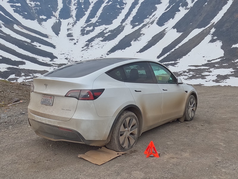
A Tesla with a flat tire at the top of Atigun Pass. We wondered what the heck someone was thinking, trying to drive an electric car this far when there aren't any charging stations and the road isn't meant for low-profile vehicles. Later, we heard that someone from Tesla may have been test-driving the car to see how far they could push it and see how its fluids and systems handled the extremes of temperature and altitudes. Not a good place to need car repair or towing, though.
Down on the other side of the pass, we parked near a river and I walked around looking for neat rocks. This back creek had an unusual name.
Jason munching on animal crackers while reading in the van. We read a lot when we don't have cell phone coverage.
We stopped in the little town of Wiseman on the way down the Dalton Hwy. It's known for its old buildings and machinery. This yard was full of old farming and mining equipment.
This fence of antlers was outside the Borealis Lodge, the nicest place we saw in the town of Wiseman. It is run by a couple who are also rangers at the Coldfoot Visitor Center, 13 miles away.
The old post office at Wiseman. This town has been bypassed by the highway and you have to take a side dirt road to get to it.
The post office has been closed since 1958, but the old log building is still a photo op.
We tried to park along a dirt road that ended at the river, but the mosquitoes were too thick. We came back to this rocky river edge and parked on the rocks near the highway bridge.
The bulletin board near the door at the Coldfoot store. It's full of stickers and we added one of ours to the mess, too.
A bicycle at the Coldfoot visitor center. We'd never seen buckets used as storage/saddlebags on a bike before! We could smell the guy riding this bike from across the room.
Our glamorous parking location in Coldfoot at the airport parking field. It was quiet and flat and convenient. And a volunteer at the visitor center took pity on me and broke out his box of paydirt that was 'guaranteed to contain gold' as he had an arrangement with a mining pal who sent him boxes of the good stuff. He gave me 3 scoops and we panned the black dirt and sand together. Between us, we only found 5 flakes, but he gave them all to me so I could come away from Alaska with some real gold that I'd panned. What a sweetie!
Next to us was a field of fireweed and this fox barley, which looked like a pink-tinged field in the evening light.
Mud from the Haul Road/Dalton Hwy. cakes everything when it gets wet. And with the water trucks spraying the road for the graders to mix in the chemicals, you can't help but pick up a coating of the cement-like goo. You need high pressure to wash off this stuff but it is mixed with a corrosive powder of calcium chloride and salt, so washing is necessary.
The fox barley tufts have a pretty lavender tinge to them.
This is a fireweed. They line the roads and inhabit the field everywhere here. It's my new favorite plant! It is often the first plant to populate the areas after a burn, hence its name. It's such a vibrant splash of color in so many places. And it turns a brilliant red in the fall. Natives say when the fireweed bloom is gone, it will snow within 6 weeks.
Fox barley in Coldfoot.
We parked along the rocky shore of the South Fork of the Koyukuk River. A place for panning for gold. Still no luck. I tried places along this river on the way up and back with no luck. At least I could walk across this river as it was pretty shallow. My socks(hanging on the Honda generator) and jeans would dry overnight.
The South Koyukuk river sees airboats as a form of travel. This one parked next to us. You can see both the vehicle bridge and the pipeline bridge here.
Another forest fire as we drove south.
This one looks close to the road to me.
Jason taking pics of the nearby fire. It did eventually close the Dalton Hwy for about 5 hours when it jumped the road. Luckily, we were south of it by then.
Some pretty yellow arnica flowers along the path.
Mixed purple and yellow, I really enjoyed the colors of the Alaskan flowers and weeds.
We stopped again at Finger Rock and talked with some firefighters stationed there to monitor this fire. We were soon breathing smoky air again.
A 'unimog' from Germany. They don't get great gas mileage, but they can get themselves out of just about any terrain. We ran across a few of these monster vehicles in our travels, often shipped to America from foreign countries.
A smoky evening sun at Finger Rock.
Finger Rock points to Fairbanks and has been used by Native Alaskans for directions for hundreds or thousands of years.
We stopped again at the Arctic Circle sign, but the campground near here where we'd stayed on the way up was commandeered by the firefighters and we couldn't stay there.


No comments:
Post a Comment