We continued heading south, enjoying the fall colors the whole way down. We focused on National Forests to find places to park overnight and then hiked the trails within.
At the Hitching Post Trailhead in southern Illinois, we smelled a stinky rotten odor. Upon investigation, we discovered this fox carcass, along with some other animal remains that appeared to have been dumped here. Strange that the head, tail and legs are still intact.
We visited Garden of the Gods Wilderness in the Shawnee National Forest in southern Illinois. Hiking a trail led us to this cave in the rocks.
Looking up through a hole in the ceiling.
A rock caught in a crack between two massive blocks.Jason at one end of a large rock arch with a hole in it.
Some cool pockets in the rock walls. The sandstone makes for a great sculpting medium for Mother Nature.
An overlook from a rocky outcrop at Garden of the Gods.
There were some really cool bands in the stone, caused by layers of mineral changes eons ago.
Jason in front of some more sculpted rock towers and holes.
Karen selfie from a rocky overlook in Garden of the Gods, IL.I think this one looks like a turtle
We hiked a long trail through the forest and hills where I found this 'ears' headband. They were sparkly and cute and some kid will probably miss them. I left them on the trail a little further along.
A purple mushroom along the trail.
Jason had picked up a rock to use to level the van. When he put it down, this giant spider crawled out from the underside of it.
A rope swing over the shallow waters near Bell Smith Springs
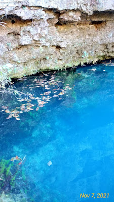
Pretty reflections beyond the floating leaves in the waters of Bell Smith Springs.
The azure color of the spring water was so pretty and unexpected. Here the ferns growing on the overhanging rocks showed some change in color for autumn.
Stone steps to get down into the canyon to hike to the Natural Bridge and Devil's Backbone. We had to eventually climb back up all 117 of these steps to get out, too. My heart was a'thumpin.
Rock hopping across the water on the trail in the canyon to see the Natural Bridge.
The Natural Bridge, a rock arch in the canyon.
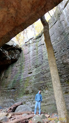
A giant tree growing up through the arch of the Natural Bridge.
A view up from under the Natural Bridge rock arch.
Karen gazing up along the tree in the arch.
We followed the trail around and up so we could actually walk across that Natural Bridge. Here I'm looking down over the edge of the rock arch.
Some funky fungi along the trail. They looked like popcorn, but are some kind of mushroom.
A very unusual tree, with spiraling bark.
At camp with our fire going, in a pulloff with a fire ring in the forest.
Trails along the tops of ridges warned us about the steep cliff dropoffs.
We parked at the trailhead for LaRue Pine Hills. A marsh backs up to the bluff, creating a unique environment for snakes, turtles and other reptiles. During September and October, the Parks Dept. closes this 2.5 mile stretch of the "Snake Road" to allow the reptiles to migrate from the marsh to their hibernation spots along the bluff. They kept it closed a bit longer this year because of the warm weather to allow stragglers to get across safely. We walked the length of the road and only saw a single turtle, still out on a log in the green swampy water.
We hiked a 3.6-mile loop created by the CCC back in the 1930s in the Little Grand Canyon, part of the Shawnee National Forest in southern Illinois . Little Grand Canyon was designated a National Natural Landmark in 1980 due to its unique ecological and geological features. Lots of water in the formations here.
We had to climb up and down some stony creek pathways, still slick with running water. Part of the trail is the actual creek bed.
An unusual formation that looks like a rock nest to me.
Lots of holes and caves in the sandstone walls.
Fall colors on the overlook.
Jason standing in front of the Pomona Natural Bridge, another arch we hiked to a few miles further south.
Both of us in a selfie at Pomona Bridge.
Hard to see the scale of these rock formations sometimes.
Frost on the field grass this morning at the Amidon Memorial Conservation Area, near Fredericktown, Missouri.
A pretty carpet of leaves on the trail for our hike today.
We visited the Castor River Shut-Ins at the Amidon Memorial Conservation Area near Fredericktown, MO. The pink granite boulders form a chute (shut-in) that funnels the water through a canyon of the water-smoothed rock. The volcanic origin of this pink granite is unusual and the pink chutes are unique.
Looking down the Castor River Shut-Ins.
Signs told us the pink granite had a volcanic origin, an unexpected formation here.
The very pink granite rock is unusual for the area and makes the place special.
The water was still and clear so we could see the pink rocks on the creek bed through the water. I love looking through the water to see what's on the ground below it.
Jason holding a sheet of ice he pulled off a puddle in the rock. Yep, it was cold.
The lovely aquamarine water of Big Spring, MO. Millions of gallons of water a day rush up and out of this opening in the rock. It's an awesome display of the power of water under pressure.
Underwater growth near the edges where the spring erupts from underground.
The water was clear enough to see the bottom of the creek. You could see all the clumps of algae growing through the water.
The water went smooth once it got away from the power of the water rushing out.
The incredible color of the water is from dissolved minerals that haven't percolated out from the water. The magnesium in the dolomite rock dissolved over many years as the water seeped its way through the rock layers, resulting in this beautiful blue. Blue Spring is aptly named.
The blues and aquas from the spring waters were just stunning!
Looking out through a hole in the rock near Devil's Well.
A pretty golden autumn reflection in the spring waters
Elk along the road.
The water at Alley Spring, near Eminence, MO was used by a mill here. This is the water coming through the chute on the side of the mill.
The historic Alley Spring Mill.
Alley Spring gushes 80 million gallons of water a day here.
Some pretty weeds growing near the edge of Alley Spring. I love the color of this water!
You can see right through the clear water and see the power of the flow with the streaming algae and water plants.
A bit downstream from the Alley Spring, with the historic mill in the background. The cliff on the other side of the creek from the mil l(behind me) was laced with caves and cubby holes.
Alley Spring Mill. The water chute is just on the other side of the building. Unfortunately, the mill was closed the day we were there.
We moved on to the Current River, another spring-fed delight. We followed a tiny dirt road down a steep hill to the site of an old horse camp shown on our map screen. There is no horse camp now(hasn't been for over 20 years we found out) and we backed right down to the edge of the river to camp for the night. This is our view of the Current River looking out the back of our van. The road leads through the river, but nobody was driving across it while we were there.Karen wading in the Current River, looking for pretty chunks of jasper and chert. I wouldn't get deeper than my knees as the current is still pretty swift here.
The only people we saw on the river, a popular kayak destination in the summer months. The smooth, swift water make it a favorite float.
Fog hanging above the river water as Jason does the breakfast dishes along the edge. Only a couple of locals came by in the days we were here. They had very few teeth, but were quite friendly and chatty. One had just shot himself 4 squirrels for "his mess" that night. We heard squirrel and chicken and dumplings is pretty good for supper.
We also visited Mammoth Springs. The humps you see in the water are muskrat dens.
The Mammoth Springs had water flowing out of both sides of the central pond like this.The old railroad station has vintage displays like these barrels on a cart. The train still comes through, too.
Purple beautyberry bush, these are so unusual looking to us as we don't see them in Michigan.
Just a few miles away in he countryside, we saw homes like this one, just heaped with trash and debris everywhere. But, they had a "Private Property" sign posted in front. We can't imagine living like this, but we saw many similar to this one.
A weird bark on a tree along one of our hikes.
Interesting rock formations from erosion near Greer Springs.
Falling Springs, the site of a 200-year-old homestead with a huge metal water wheel.
Apparently, folks weren't as tall as Jason back in those days.
Vandals have shot up the water wheel, but it's still impressive.
Lots of little caves in the limestone hills all about.
We couldn't believe the size of these sycamore leaves in the area.


No comments:
Post a Comment