Jason and Karen on a hike up to Spy Rock, near Redding in the Ozark Mountains of Arkansas.
On top of Spy Rock, after a 2.5 mile hike uphill all the way. Our last stop in AR before moving into Oklahoma.
Near Billy Creek recreation area, this swimming hole looked inviting. You can see the stepped bedrock through the aqua waters.
This national forest sign has been engulfed by the tree growing around it.
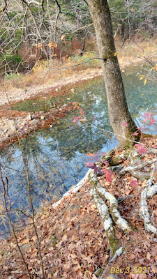
A nice reflection scene.
I hadn't realized the Native Americans could issue their own license plates.
Cute sign near Heavener, OK where we stopped for a lunch break.
Locals told us about the Runestone Park and we went up to have a look. These flower containers each sport a different rune sign.
This huge 12' slab of sandstone is housed in its own protective building and is viewable behind a glass wall. The Vikings apparently got all the way up into this area of Oklahoma way back in 600-800AD. These markings have been translated as being a boundary marker or land owner's claim from back then.
The Viking ships are thought to have come up the major rivers in their flat bottomed boats and several of these rune stones have turned up in the area.
A pretty blue creek next to our camp site at Billy Creek. The park service guy we asked about dispersed camping told us this campground was free, and two others we were hoping to stay at were closed. We get good info talking to the park and forest service personnel, whether they are greeters, fire control persons or law enforcement.
Our camp ground was next to a horse camp, full of senior ladies who ride together. Jason wouldn't touch the horses, but we watched as they saddled up with the help of saddle racks and winches and got ready to ride.
A sign by the horse camp regarding the speed.
We decided to pay for a campsite with water and electricity near The Lake of the Arbuckles in the Chickasw National Recreation Area. The Buckhorn Campground had heated bathrooms and hot showers to clean us, and Jason hooked up the hose and gave YOLO a bath, too. The $11 was well worth it for us to clean off the dust.
At the Travertine Visitor Center near Sulphur, OK, we encountered this bison with his mask on.
This is the Buffalo Spring, still bubbling up and clear, surrounded by improvements made by the CCC back in 1930's. The tribal leaders gave the lands to the US Gov't with the provisions that the public could come and get access to the spring water for free.
The trails through the springs area were easy.
This is the actual Antelope Spring. I put my drinking bottle down into the water and collected some for my drinking pleasure. I figure this is about as pure as water can get.
The springs flow out over the boulders into a larger area where it forms pools where people come to swim in warm weather. A kid jumped in when we were there (I think his Mom may have pushed him in), but lasted just a few seconds before he climbed back out.
Jason on a walkway across the water before it flows away in another stream. You can see that kid climbing out in the background. The park has a 'beach' there for folks to enjoy these waters in summer.
We decided to try the idea of parking overnight at a casino. The security supervisor at the Chisholm Trail Casino in Duncan, OK told us the best place for us to park and later came over to chat with us about our van and travels. He is a Cherokee working for the Chickasaw tribe. The Chickasaws are the largest employer in the area, surpassed only by the US Gov't. The largest casino in America (bigger than any in Las Vegas even) was about an hour away, but we weren't going that direction and let it pass. Here Jason is relaxing and checking for a wifi signal from the casino in the background.
A huge metal statue in front of the Museum of the Great Plains in Lawton, OK. We thought we'd stop here, but it wasn't yet open for the day, so we drove around back and found the Comanche National Museum Cultural Center already open. Junior came out of an office and gave us a long-winded history of the Comanche people and answered any questions we posed.
We spotted a sign that said 'Holy City' and didn't know what it was, so turned off to find out.
It's a huge, life-sized setting for an Easter Pagent that tells the story of Christ in Jerusalem.
Some buildings, like the chapel are functioning buidings made of local stone. Others are just elaborate facades and props for the play.
The place was large and spread out and empty the day we wandered around.
This facade represents Herod's Court, but behind it was an empty land of rocks and weeds
As we left, Jason spotted this buffalo/bison laying in the sun in the tall Indian grass next to the road. We stopped briefly to get the photo, but didn't want to disturb him enough to get him up.
Wind and age have taken their toll on this old cabin along the road.
Cotton was a crop we saw a lot of in Oklahoma. Here, the pink bales await pick up.
Mud cliff swallow nests along the beams of an overpass next to a river. We followed a dirt track that went under the road along the river, but it ended up at a private property. These were like Mother Nature's pottery art.
The picnic area in a nearby campground was empty except for these deer, practicing their head butting.
North of Cheyenne, OK we found the Black Kettle National Grasslands Visitor Center. Lots of artifacts about the massacres of tribes camped along the Washita River. Black Kettle was one of the Chiefs who wanted peace, but ended up getting killed in a raid by soldiers. Karen sitting on a soldiers hard wood and rawhide saddle
Jason at the site of the Indian camp where the massacre took place. The trees were festooned with prayer flags, but a sign said it was considered disrespectful to photograph them; you can see a few along the margins that were captured in the frame.
We saw what we know as 'camel melons' growing in the weeds along some roads and in fields. They are considered an invasive species, a weed that should be ripped out. We first encountered them in the outback of Australia where the camel trains had dispersed the seeds in camel poop. The fruit is toxic to animals and people.
We'd met a local in Cheyenne, Jimmy, who found us at the Visitor Center after our hike and offered to take us to "see something not many people get a chance to see." We took an ATV across the acres of his mother's ranch to get to an old homestead building known locally as 'the hermit house'. Jason and Jimmy's son just after we arrived at the unusual building.
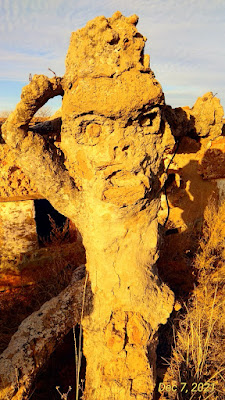
Jimmy is pointing out the 2-sided statue in front of the home. This is the female side. It is a naked woman sitting with her legs crossed.
This is the male side. The clay and cement statue was once anatomically correct and the story to told us related how some church women were offended by the existence of the statue and claimed it was corrupting their children. They pressured the local sherriff at the time (it was an election year) to bring them out to the home so they could destroy the statue. The owner was an Austrian immigrant who'd become a citizen, homesteaded this land, kept to himself, and built this home and statue by himself. He sat and cried as the church ladies smashed his work as there was no one to turn to to help him. His name was Josef Muhlbacher and he inscribed his name and 1920 into the window sills of his unique home. He played the accordian and high schoolers used to come out and dance on his roof to his music. The roof was flat and shingled with old license plates.
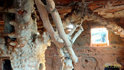
The inside of the house was even more bizarre. Jimmy is pointing out some of the unusual features to Jason inside.
This sculpture is the centerpiece of the main room. A central 'body' with legs that spiraled out to the edges of the room. Its texture reminded me of king crab legs.
A statue of a man was carved into the ceiling, as was a hand that looked like it could reach down and grab you. The man's head is at the right, feet to the left
The crumbing supports for the center structure were just very strange.
The carving of the date 1920 in a window, tell us when the house was built.
This is the view of the home as we drove up. The round thing on the roof was a lookout tower before it collapsed. Supposedly, Joe Muhlbacher was paranoid that the Brits or Germans could attack, so he wanted to watch for them.
The windows were round and meant to look like cannons facing out to repel attackers.
One wall of his barn still standing. A thief set fire to the place years ago to create a diversion while he robbed the drug store in the town. All the officials were drawn out here to fight the blaze and he made off with his loot. The fire blew out the glass pictures he had hanging on the walls and ceiling and pretty much destroyed the place.
The construction of the walls was very unusual--balls of red clay set in layers between mortar and cement. There were little balls of red clay everywhere. Nobody knows if it is a natural phenomenon here or if he spent his days rolling the balls by hand. This room was where he kept his cows, pushing feed through the window and hanging a water bucket on the nail in the wall.
A few wood beams are all that remain of the roof of the barn. Folks thought the unsocial hermit must've kept gold hidden here, so after his death and the fire, looters tore the place apart looking for non-existent gold.
Most of the place is now in ruins, but the stories and remnants of the hermit's artwork remain. The red-headed recluse was an oddity and more about him and this unusual home can be found by Googling his name, Joseph Muhlbacher.
A 1925 Oklahoma license plate that once was a shingle on this homestead dugout home. A curious traveller once wanted to buy a few for $5 each and the current owners let him pick out a few. The next week, the entire set of license plates/shingles were gone--the man had returned and stolen them all. This one was missed.
Jason and Karen posing by the statue in front of the house.
Jason looking at a large fountain statue at a corner of the home. The man was quite the sculpture artist.

Jason and Jimmy back at the farmhouse. That is the ATV we took across the fields to reach the unusual clay hermit house.
One of Jimmy's relatives told us about a ghost town her family owned, Texola, OK. We drove the hour to the old decaying town the next day. This artistic brickwork caught my eye.
Another old building in town had these old shelves inside
The colorful painted doors were left unlocked. The lady who told us about the place said much of it will be bulldozed as the buildings are rotting and decaying with nobody putting any care or maintenance into them. They don't want them to become dangerous.
Texola is on the Texas-Oklahoma state line, and has been part of both states, back and forth, depending on the latest survey. This sticker-clad sign was at the edge of town.
Also on the edge of the weed-choked road in town was this sign, noting that the Historic Route 66 through town is also known as the Will Rogers Highway. He was born here, but even his fame couldn't save the town of Texola when the new Interstate 10 bypassed it years ago.
An old truck advertising Tumbleweed 66 gas station. I'm not sure if the emblem on the truck represents Route 66 or Phillips 66 gas station. There was nobody around to ask; just lots of dogs barking.
 |
| A well known sign on the side of a building in Texola: |
"THERE'S NO OTHER PLACE LIKE THIS PLACE, ANYWHERE NEAR THIS PLACE SO THIS MUST BE THE PLACE"
Another sign on another closed building.
The restaurant was one of the last businesses to close here.
We went back to Cheyenne for another lunch at the Senior Center there, where we'd met some nice, interesting folks. They told us we could park in the City Park overnight. We enjoyed the music-synchronized Christmas light scenes along the road through the park.
We bypassed the campgrounds in the National Grasslands as they didn't really have level places to park except the parking lot and it didn't look terribly interesting. So we moved on to find another place. We had to climb over a locked gate to hike the trail indicated on a map and found a herd of grazing cows not far down the path. This jawbone (my guess is from a deer) was laying in the grass along the path.

Big winds were forecast and we chose to hunker down at an abandoned campground near Hardesty. We'd stayed at another abandoned campground, Gopher Point, the night before, sheltered from the winds by a big juniper tree. We were in a Wildlife Refuge Area, but never saw any wildlife of any sort, unless you call rolling tumbleweeds wildlife. We'd seen this campground across the valley in the binoculars and moved to this spot the next day to avoid the higher winds forecast. We had a row of junipers in front of us and a small hill to one side, and this juniper and tree on the other side. We had to clear the tumbleweeds from the site to back into it so we'd be facing the wind. The tall weeds grew up through the old asphalt and the concrete picnic tables had all been removed. Part of the roads shown on the map to get here no longer existed, but we found this spot and it was ideal for the night.
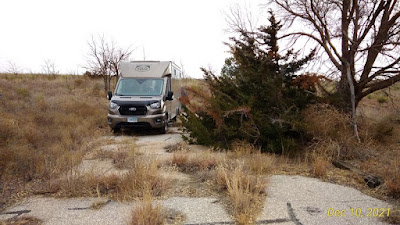
YOLO backed into a protected spot at Hardesty Park campground, an abandoned campground that is free if you can find it.
More Oklahoma cotton. This stuff was all over the roads and sides of the fields. Even with all the sticks and grass and seeds in it, it is so soft.
The tumbleweeds blow up around and under YOLO.
Another bleached skull and jawbone of an animal....a cow? It's a hard life in OK for cattle.


 One of Jimmy's relatives told us about a ghost town her family owned, Texola, OK. We drove the hour to the old decaying town the next day. This artistic brickwork caught my eye.
 Another old building in town had these old shelves inside
 The colorful painted doors were left unlocked. The lady who told us about the place said much of it will be bulldozed as the buildings are rotting and decaying with nobody putting any care or maintenance into them. They don't want them to become dangerous.
 Texola is on the Texas-Oklahoma state line, and has been part of both states, back and forth, depending on the latest survey. This sticker-clad sign was at the edge of town.
 Also on the edge of the weed-choked road in town was this sign, noting that the Historic Route 66 through town is also known as the Will Rogers Highway. He was born here, but even his fame couldn't save the town of Texola when the new Interstate 10 bypassed it years ago.
 An old truck advertising Tumbleweed 66 gas station. I'm not sure if the emblem on the truck represents Route 66 or Phillips 66 gas station. There was nobody around to ask; just lots of dogs barking.


 More Oklahoma cotton. This stuff was all over the roads and sides of the fields. Even with all the sticks and grass and seeds in it, it is so soft.
 The tumbleweeds blow up around and under YOLO.
 Another bleached skull and jawbone of an animal....a cow? It's a hard life in OK for cattle.

No comments:
Post a Comment