Fairbanks, Alaska is a nice sized town. Construction on part of a major highway here made it difficult to maneuver in part of town. The Antler Arch is just off the visitor center here. I'm standing below 100 antlers from moose and caribou.
We walked around the town along the Chena River. This statue of Eskimos was one of many scattered around the area.
A bridge over the pretty river in town. You'd not realize how much damage this river did when it flooded years ago.
Grass and weeds grow out of the roof of a building downtown.
Jason walking aound in Fairbanks. ots of log buildings everywhere.
Beautiful flower baskets hung outside this one.
I really like the colors of these blooms against the wood.
Distances on a pillar in downtown Fairbanks. Yep, we're a long way from home.
Fairbanks is known as the Golden Heart City, at the end of the Alaska Highway, 1523 miles from its beginning back in Dawson Creek, Yukon.
Ravens are a popular theme here. Lots of the huge black birds call Alaska home. this one is metal/wrought iron, and built into a fence.
Lots of pretty murals around Fairbanks, too.
This colorful building stands out downtown.
A strange name for a popular store in Fairbanks.
A scenic quilt someone put a lot of work into.
At the junction, we had to head towards the Yukon river when we left town. Signs here seem to be a target for vandal shooters. It was too high for me to reach to add a sticker from YOLO.
The start of the Dalton Highway, aka The Haul Road. More bullet holes and stickers.
The newer, official start of the Dalton Highway. Tradition says you take a photo at the start and then again at the end of your journey up and back along the road. Jason is still smiling.
YOLO van at the beginning of the journey up the Dalton. Still clean.
Heavy smoke created a layer that covered the sky for miles.
This is Yukon Crossing. It's a prefab trailer with a restaurant/coffee shop/gift shop with a gas tank off to the side. That's it. One motorcyclist we met at the Arctic Circle said he couldn't believe he'd missed the only gas station between Fairbanks and Coldfoot. He was running out of gas and pouring his reserve fuel in so he could get back to here to fill his tank. I could understand how he missed it as it was just a tiny dirt road turnoff, badly signposted, and he was looking for a traditional 'gas station'. This isn't one, so we explained what to look for and he headed back the way he came.
Huge metal 'headache bars' prevent vehicles that are too high from driving up to the pipeline. If you can fit under these metal bars, you can fit under the pipeline.
A sign in the Yukon Crossing visitor kiosk.
The artesian water spring they keep flowing for drinking water for travelers and passers by. We filled our jugs with the icy cold water a few times. Had to fight off swarms of mosquitoes while filling here, though.
We spent an evening with other vanlifers, swapping stories and drinking scotch and beer around the fire.
Lentil stew from the Instant Pot for dinner.
Finger Mountain is an ancient chunk of granite that sticks out of the ground. It is called a 'tor'. It points to Fairbanks and ancient native travelers used it for direction. Jason walked out to the actual rock formation even though the visitor center lady warned that bears may be hiding in the alder bushes that grow between the visitor parking and the rock.
Finger Mountain as seen from the parking lot. Other interpretive panels highlighted other plants and animals around here on a short hike to the top of another mound of rocks.
The sign at the latitude of the Arctic Circle.
YOLO and Jason at the Arctic Circle sign, a must stop for travelers on this road.
A brand new/recently renovated campground was open and we were the only ones here for a while, other than the persistent mosquitoes. Wearing the hood helped and then we only had to worry about our hands getting bitten.
We cooked cheeseburgers and a can of corn over the fire on the brand new grill at the campground.
A caribou hide discarded next to a river where I went gold panning along the Dalton.
You can barely see the sun though the heavy smoke from wildfires. And it was up all day and all night!
The airboat that scared me on the Koyukuk River. I was panning for gold on the other side of the river under the bridge.
This notice was posted one afternoon by a BLM employee. It was soon defaced by an angry local who used this rest area. The idea of packing your trash for hundreds of miles up and back down this road seems ridiculous to me. They don't realize what a hardship this would be to the all the camper vans traveling this road. The sign was gone when we came back down the road, but we did start to see fewer trash cans.
A local flightseeing and air service in Coldfoot. I just liked the sign.
These floatplanes take hikers and rafters up into places you can't drive to easily for their adventures. I joke that they just give mosquitoes a set of skis and call them floatplanes up here!
The old visitor center in Coldfoot, Alaska. Everyone stops here on their way up and back as it is the only gasoline available for hundreds of miles. Next station on the way up is 240 miles away.
An old tank outside the store made to look like a pig.
This is the hotel in Coldfoot. Just prefab buildings linked together, built above the permafrost.
This motorcycle is so dirty you can't read most of his stickers. The front of the rider was in similar condiiton
The side of the old visitor center. Antlers are a very popular decoration here.
The old wood is warped and peeling. The new visitor center is a state-of-the-art building that was incredible.
The view of the shop/gas station and restaurant that is Coldfoot. What you see is what you get.
An open field next to the hotel is the landing pad for helicopters.
Signpost at the corner tells you where we are.
Sourdough fuel has the only gasoline available here. 'Sourdough' is a term given to folks after they have survived their first winter up here. You're a 'cheechako' until then.
Gas up before you head up to the end of the road to Prudhoe Bay. You can't actually drive up to the Arctic Ocean at Prudhoe Bay. You can get within a dozen miles at the camps in Deadhorse, but then you must take a paid tour shuttle to the actual ocean shore. The road goes through the actual oilfield with their pumps, so you must clear security and wear safety goggles and restricy your access to the East Dock area when you get out. It's private oil land.
Hiking along the river before we started uphill to the Marion Creek Falls.
The hiking trail crossed many rivulets of water as we worked our way up in elevation.
Marion Creek Falls. We couldn't step any farther out as the edge of the bank was soft and unsteady. A wrong step or a slip could be deadly here.
The water plummeted over big sharp rocks on its way downstream
The two ladies who were also hiking up to the falls ahead of us. Jason is leaning out to get a photo, but viewing was limited by the terrain here.
Jason and Karen (with her mosquito hood on but flipped up) at Marion Creek Falls.
A bear paw print in the mud at a mining claim site on our way back down the trail. We took an old mining road down to avoid the boggy hike across the tussocks on the way back.
We had to wade across this creek to continue on the way down.
Jason before we got wet wading across the swift-flowing river.
Jason making his way across the rocks as far as he can before wading into the water. Notice the trees leaning on the bank. The high water is eroding the banks and the trees will eventually fall across the water. Such trees can force the water to change direction, causing the braiding of so many of the rivers here.
A moose skull at the mining claim site across the river.
A proper staked mining claim notice, with the redneck warnings posted below.
A cool design in a rock. Heat and pressure squeezed the contents of the vein and smeared the rock in the fissure, creating this design that looks like a snakeskin on the rock.
Purple pinecones on a spruce tree. I don't know why they're purple, but they surely were pretty.
Jason hiking down the road back towards the van.
The color of the water is a pretty aqua and it's quite clear.
Sharp peaks along the road make for dramatic scenery.
Road damage along the Dalton Hwy. Looks like a giant tried to tear off the asphalt, leaving huge cracks and uneven roads. Frost heaving is probably the real culprit.
Looking across the tundra and spruce to the rocky cliffs beyond the North Slope.
YOLO parked along the road for lunch with a scenic backdrop.
Mounds earth on the otherwise flat tundra are called 'pingos' and are mounds of ice that have pushed up from the permafrost and been covered with soil.
The ice along the edges of a river. Only the center shows the water running beneath it.
Rocky spires above the tree line. Tree line here is much lower because of the latitude. Trees stop growing above 2250-2300 feet up here. For comparison, the tree line in Colorado is nearer 10,000 feet.
A semi rolling along the dirt road brings a cloud of dust with him. This is a dirty road to travel and we brought along lots of the dust with us.
Another view of the pointy mountain tops.
A rocky riverbed in front of a glacially ground mountain.
One of the pump stations along the Alaska Pipeline. They have over a dozen of these massive operations along the pipeline that make sure the oil keeps flowing.
That is white calcium chloride they dump on the dirt and gravel along the roads here. It keeps the dust down when wetted; they use a similar technique on the sandy roads around our cottage in Michigan.
Road graders mix the calcium chloride into the dirt/gravel mix so it hardens into the road surface.
The dirt ridge formed by the bulldozer created a dangerous ridge in the middle of the road. We got caught on the wrong side of one of these ridges when a trucker came barreling at us from the other direction. Scary. We made it to the end just before he reached us. Such a dirt mound caught a motorcyclist we met later and dumped him and his bike, breaking his ankle and dislocating his shoulder. This road is known to be dangerous!
One of the trucks used to spread the calcium chloride. A bulldozer lifts and drops huge Tyvek bags of the stuff onto the spiked protrusion above the hopper and the salt mix spills into the truck to be spread as he drives away.
The rocky river along the road below Atigun Pass.
The weather deteriorated as we began the climb to the pass. Rain and smoke create a haze.
Still ice and snow on the Atigun Pass along the road.
Small glaciers and ice/snow fields create avalanche dangers in the winter months.
We got above the clouds as we wound our way up the pass switchbacks.
We encountered fog, rain, and sleet near the top. Vehicles are required to have their headlights on at all times on this road. Luckily, we encountered very little traffic and we took it slow without vehicles pushing behind us.
The peaks were shrouded in cloud as we descended down the other side of the pass onto the famous North Slope.
It's mid-June and there is still plenty of ice along the rivers and in the shadows of the mountainsides.
Rocks are almost all you can see of this old riverbed that comes all the way from the old glaciers back up that valley.
The North Slope tundra now replaces the spruce forests on the other side.
Peaks sharpened by gouging glaciers haven't yet been worn down by time and weather. So many jagged peaks surprised me.
The Atigun River flows wide and smooth, but his sign warns that there are very dangerous rapids just around the bend from here, so don't be fooled by the placid waters.
Coming up to Galbraith Lake on the North Slope. Scientists come from all over the world to study the ecosystem here in the tundra as it is one of the best examples of the natural environment accessible to study.
The clouds form a layer that doesn't reach up to the peaks
Clouds circle in the air of a mountain cauldron.
Clouds in the hills. Not the best weather.
The dirt from the Dalton Hwy coats the back of YOLO.
YOLO was filthy and we wanted to wash off all those chemicals from the road.
Our camp spot at Galbraith Lake Campground on the North Slope in Alaska.
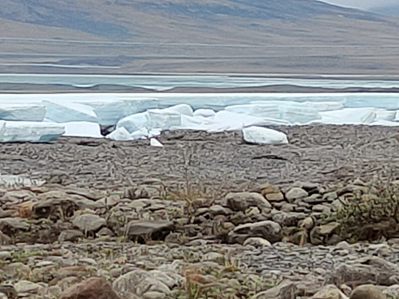
These chunks of ice along the river are called 'auf-ice', It's from the overflowing water when the river freezes. The water squeezes up and out of cracks in the river ice as it cannot penetrate the permafrost below. It overflows the river banks and builds all winter. It gets left behind on the banks as the river waters flow away in the spring. These huge chunks and walls of ice are over 10' high and will remain well into the summer here. We heard a large chunk break off and felt it hit the ground below.
The river was a rocky one with lots of gorgeous conglomerate rocks and pretty green rocks.
The auf-ice went farther than we were willing to hike to. We didn't want to wade through the water, but we found places to rock hop across the smaller rivulets to get across.
An example of a boulder of conglomerate rock. In Michigan, puddingstones similar to this one are prized finds.
Weird circular depression in a rock on the riverbed.
Our view of a peak from Galbraith Lake Campground.
A strange hole appeared where this metallic bit has rusted out inside this rock
The tundra landscape of our campground surrounds. Lichen, moss, and spongy peat made for a soft, soggy walking surface. Arctic ground squirrels love this kind of terrain. We watched a family of them for hours near our van.
The bright yellow lichen stands out amongst the flowers and other mosses and lichens. The natives used to trade a dried yellow lichen to settlers and others to use for color/pigments in paints and decorations.
Some caribou bones spread around an area near our campsite. Plenty of bear scat around, but we never saw the big animals here.
We enjoyed the free camping at Galbraith Lake for a few days before carrying on north.


No comments:
Post a Comment