We left Dawson City after the ferry crossing of the Yukon River and headed north to the Top of the World Highway, an 80-mile dirt road that is not maintained in the winter. We had to keep asking about conditions for it as nobody had been all the way across it for a while. The other end of the highway is the Alaska-Canada border crossing that had been closed since 2019, so we were going to be one of the first few through it if we could get across this dirt highway.
These empty facades of old buildings act as billboard to advertise Dawson City to folks coming from the other direction.
The Fortymile Herd is a herd of 100,000+ caribou that range up and down the Alaskan countryside with the seasons. We never saw the huge grouping. The Fortymile River, though, was one of the richest gold-producing rivers in the era.
We parked overnight next to this oldtimer's sod-roofed cabin. It's not in very good shape anymore.
Our wayside parking spot next to the cabin remains.
These cheeky grey jays weren't afraid of us at all and came right in for a bite of our dinner.
They seem to like chicken. I know we aren't supposed to feed the wildlife in Alaska, but how can you resist this cute face?
Jason at the top of the world.
My snowbank graffiti along the Top of the World Highway.
Jason and his mark left on the highway.
This dirt highway from Dawson City, Yukon to the Alaska border is a famous route.
The last scenic view stop before the border, complete with a STOP sign at the pulloff. Really?
The Alaska-Canada border entry. The big yellow things are radiation detectors. Like someone would be smuggling radioactive stuff across the border????
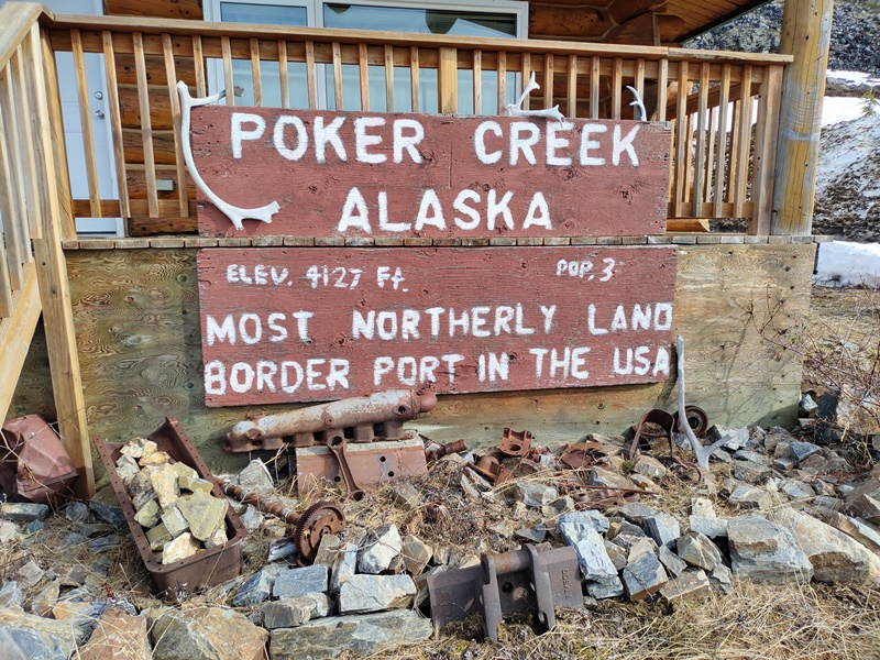
Poker Creek, aka Little Gold on the maps, is the most northerly border crossing in the US. It was just reopened after 3 years of closure due to COVID.
The border crossing officially opened the day before we used it.
We finally made it to Alaska!!
I couldn't wait to try gold panning. The first place we stopped had these funny blue stones in an area where we parked. I think it was part of someone's old camp, and I don't know what these are.
The first creek I tried between the border and Tok, Alaska. Got zip.
Try keeping an Alaska highway cleared with this old snowplow.
We'd heard of Chicken, the first town we reached inside Alaska.
This was the view of the Yukon River as we left Dawson City and started on the Top of the World Highway.
An old dredge, now broken and derelict in the river, as seen from a bluff above on one of our hikes.
Karen on the hike to the river bluff.
YOLO parked behind a couple of huge metal chickens in Chicken. The founders wanted to name the town Ptarmigan, but nobody could spell it, so they gave up and called it Chicken instead.
A sign outside the store in Chicken.
It seems every building in this town, with a population of only 13, sports a chicken of some sort.
Moose antlers laying next to one house.
A scrawny metal chicken on top of the old gold camp sign.
The dredge used for getting to the gold in Chicken.
The size of the chain links on the buckets of the dredge is pretty huge.
Some creative metal worker kept the chicken theme alive with these pipe tops.
The huge town mascot chicken, Eggee, is made of recycled metal school lockers.
The signpost with chicken-related towns around the world.
The Chicken signpost and metal chicken sculpture on a hill in town.
Another metal sculpture outside the store at Chicken.
Golden eggs for this chicken welcoming visitors into the store.
The 3 big draws for this town of Chicken--the metal chicken, the signpost and the old gold dredge.
Someone did a good job on the recycling. OK, enough of the chicken....
A caribou foot found in a wayside pullover where we stayed.
Jason reading the interpretive panels about the Tanana River Bridge building. The Tanana River is a big one in this area. Natives used the frozen rivers as highways, making it much easier than trying to get around and across the area when it wasn't frozen.
The view coming to the Tanana River crossing. Spectacular.
I couldn't resist a scenery shot, even though this one has telephone wires in it.
The giant Adirondack chair welcomes us to Tok (pronounced Toke).
So many buildings here are made of the spruce logs from the trees that grow here.
Our first moose sighting, in a gazebo at Tok.
We finally got cell phone service again here in Tok, and Jason is using it at the gift shop store.
The inside of the store was like a museum. This old hide and timber musher sled hung from the rafters.
Awesome scenery as we drive.
Stopped at a campground/recreation area for lunch and these kids were braving the waters already in June.
What a backdrop for a night's parking, eh?
Jason waiting for me on a hike. He found a soft, cushy spot of lichen and moss to relax upon.
Vertebrae from a moose or bison, scattered across an area near where we camped.
Spruce tips, the new growth on the white spruce trees here are used to make teas, rubs and to season foods. I chopped them up and used them like rosemary to season meats in my Instant Pot. Tea made with these tastes like a sip of Christmas morning! You have to harvest them before they spread out and grow.
Millions of acres of forest were on fire when we were here in Alaska. Nearly 3 million acres had burned. The state is too big to try to fight them unless they endanger people or structures.
We stopped for lunch and a quick walk down to the river at this boat ramp.
They weren't kidding they said it was for 4WD only. The steep ramp just dropped off about 3 feet where Jason is standing and the swift river current looked very unforgivable. I don't know how it is even usable.
The inside of a piece of paper birch. The outside is white, but the inside is a pretty copper color.
One of the many bridges over rivers here in Alaska. Access to the rivers at either end of the bridges became one of our favorite places to stop, and sometimes stay the night if there weren't 'No Overnight Parking' signs,
Upside down scribbles in the golden mud along the river.
A metal art sign in a store.
The Milepost (our guide book/bible of the highways in Alaska) said the Delta Meat Co. gave free samples of their sausages. No longer true, thanks to COVID, but we did buy some spicy buffalo hot links here.
One of the visitor center buildings at Delta Junction.
An old rubber plug used to clean the inside of the Alaska Pipeline. They shove the plug in one spot and wait for it to come out at another spot, sort of like reaming out a septic line. Modern ones have sensors attached that also measure the thickness and condition of the metal pipe so they can do preventive maintenance if a pipe is getting thin. They don't want leaks.
These foam and metal mosquitos are almost life-sized.
A clever way to warn motorists of bison on the roads. Yes, the bison still roam free up here and there is a big herd that loves to graze along the roadways.
Delta Junction is the end of the Alaska Highway that started in Dawson Creek, Yukon. We traveled all 1422 miles of it! And we're just getting started.
A sign on the Delta Junction visitor center. Steppe bison still wander in these areas and you have to watch for them along the roads.
A stuffed steppe bison, pretty much like the buffalo of the old west, just in a different environment.
Jason at the Delta Junction marker.
Trimming the shrubs isn't a high priority at the visitor center.
We will be taking the Richardson highway north towards Fairbanks.
Another old snowplow from the 1940's.
An old piece of road machinery used to try to keep the dirt and gravel road flat.
This old steam shovel looks like a cartoon rendering of one. All the old equipment was used in the making of the Alaska Highway, a truly epic feat of roadmaking in record time in the 1940's in unimaginably horrid conditions most of the time.
Rhubarb grows great here and is used as an ornamental green. This and the old equipment is at the old Sullivan Roadhouse, seen behind the rhubarb.
The first sighting of the Alaska Pipeline, suspended over the water here on its own bridge.
A big sign gave us details about the pipeline. It was built 50 years ago and only had a life expectancy of 20 years. The oil company consortium now has to keep it running as there is no way they'll ever get the permits to replace it now or build a new one.
Jason taking closeup pictures of the flowers along the ridge above the Tanana River.
More burl wood sculptures at the Knotty Shop. Large-as-life mosquito.
A turtle
A bison
All the pillars and posts here are made with the birch logs with burls in them.
Giant moose antlers atop a wooden moose face. This was a cool place and I enjoyed my first ice cream in Alaska here.
Inside the shop was a taxidermist's dream. All the native, local mammals were shown in this scene of stuffed animals along a wall.
Linx, caribou, bears, wolverine, fox, wolf, and others were all here.
Even Sasquatch got a furry representation here.
Good advice from a moose, on a card for sale in the shop.
Next stop was the North Pole, Alaska.


.jpg)


No comments:
Post a Comment