Jason uses a GoPro camera and takes a few photos once in a while, too. I usually don't have his photos from his chip available when I update the blog, so thought I'd put a bunch of his pics out here for your perusal. Some might be duplicates, but I'll just let you scroll through them.
Karen at statues in main plaza of Aguas Calientes, the gateway city to Machu Picchu.
Llama steak and corn soup made for hearty meals before our visit to Machu Picchu.Karen was delegated to be the leader of the group for the 11 AM bus. The tourists had to follow me down the hill when the time came to catch the bus that would get us to the entrance to Machu Picchu at 11:00. Everything here is timed and scheduled so people aren't clogged up at any one spot.
The first thing you see when you enter Machu Picchu--the Gatekeeper's Cottage. It was one of my favorite buildings, so quaint looking for this place.
Karen with the iconic peak in the background.
Jason's postcard picture at Machu Picchu.
The Inca Bridge, an optional trail Jason took along the edge of a cliff at Machu Picchu.
More of the cliffside Inca Bridge.
View from high up in Machu Picchu.
Terraced village of Machu Picchu.
Karen resting on a stone stairway at Machu Picchu. Everything is made of stone here.
Stone buildings at Machu Picchu, Peru.
Tons of terraces. Those are all people down there if you look closely.
Temple of the Condor at Machu Picchu. A rock formation that supposedly looks like a condor.
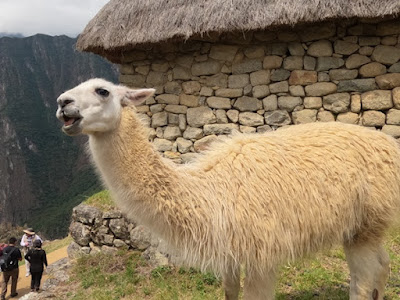
The llamas used to roam freely here, but this one was munching alongside the pathway where us tourists were passing.
A scary mask on the wall of the Peru Rail train.
Karen on the Peru Rail train to/from Machu Picchu.
Dancers entertained us on the train.
Smiling dancers on the train.
The ruins of the granary above Ollantaytambo, the place where we caught the train to Machu Picchu/Aguas Calientes. Jason climbed up above the ruins but I stayed at the resting place down the path.
View from the granary above Ollantaytambo in Peru.
Looking cross the town to the Temple of the Sun Incan ruins at Ollantaytambo in Peru.
The Maras Salt pans. A salty fountain releases water at the top of the hill and local families have directed it into pans all down the slope of the hill for thousands of years.
The salt is collected and bagged and sold to vendors locally and overseas.
The brown water is the raw salt water. As it dries, it turns white as it crystalizes into salt. The salt is then scraped off and bagged and stored in the local warehouse until it is sold.
A man at the bottom of the path makes figures like these llamas out of hard blocks of salt and sells various flavors of the salt in bags.
These men in town below the Maras salt pans were busy making big mud bricks in the street. They squished the mud/straw mix into rectangular wooden forms and then lifted the box off, leaving the bricks in the sun to dry.
Guinea pigs at Pinca in a corner of the old bakery that has been operating since 1830. Guinea pigs are called 'cuy' here and are a food item.
Fresh hot bread rolls still come out of the ancient wood-fired oven here. Tasty.
Schoolgirls near Palccoya waiting in a shelter for their rides home.
This one was shy to smile.
A sphinx rock formation at Ischigualasto National Park.
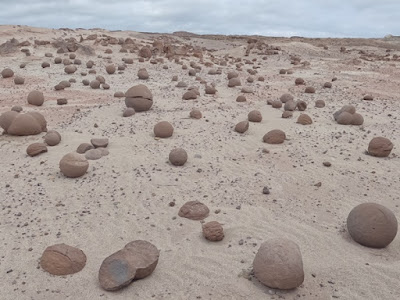
A field of round concretions in one area of Ischigualasto park.
The submarine formation in the park.
Karen enjoying the rock formations here.
The mushroom formation in the park.
Karen holding up the mushroom?
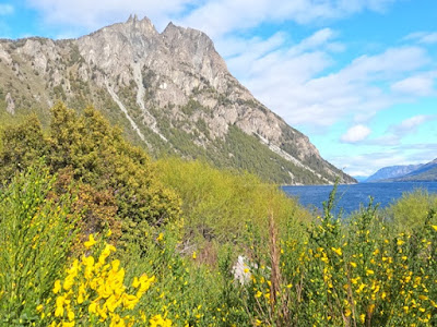
The green and gold against the blues of sky and water were eye-popping.
More roadside color from one of our campsites.
We hiked up to see this view. Amazingly beautiful.
Riding the Old Patagonia Express train in Esquel.
Chickens at Teros Ranch.
Darguina, the pig at Teros Ranch. Gustavo, the owner, has had her since she was a tiny piglet.
Negative hand paintings at Cueva de las Manos/Cave of the Hands. They are thousands of years old!
They are so well preserved because they are on the walls and ceilings/overhangs of the rock where the sun, wind, and rain don't reach them to degrade them. Vandals and graffiti were the biggest threat until UNESCO declared it a protected site in 1999.
A chimney rock at the edge of Caracol Chico Canyon. Karen is at the base of the rock formation.
A guanaco that didn't clear the fence. We saw hundreds of these that hang until they turn to skeletons. They get caught on their back haunches and can't get off if their back legs don't clear the fence when they jump over it. Sad.
One of millions of grasshoppers we saw that were swarming the road along parts of Route 40 South. We've never seen so many! And they didn't fly, so we're hoping they aren't locusts.
El Chalten in the valley below the miradors.
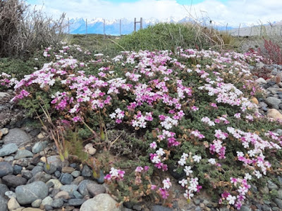
Purple and white blossoms on a green ground cover were another pretty distraction for the eyes. Nice how the colors blend so easily.
Fitz Roy is the big peak in the middle. It's the highest in the area.
Looking down for a change into a canyon where a river flows.
Looking down over 28 de Noviembre from the overlook on the hill above town. The ladies here gave us tons of sweet pastries for free and the tourist info center gave us a lump of coal (big coal mine nearby), a dashboard plastic Andy the Condor statue (this is the condor capital of the region), and stickers and a woven wall hanging. We enjoyed their hospitality for three days while waiting for winds to die down again.
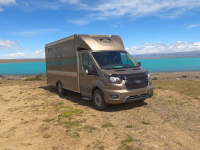
YOLO parked next to an aqua lake fed from the glaciers in Patagonia. This is Lago Villarino behind us. We had the place all to ourselves for the night.
Perito Moreno glacier in Glaciers National Park. Another overcast day, but I think the cold air from the ice sheet keeps forming the clouds above it. We even got a bit of snow from the overhanging weather cloud.
Looking to the right from the viewpoint. We saw chunks calve from the side here.
The dark stripes in the ice is sediment the glacier has picked up over the years. The dark blue is the compressed ice at the front of the edge of the glacier up against the rocky edge of the canal between us and the ice.
Looking to the left of the glacier, the water on this side of the canal was more brownish-grey. You could see pools of the different colors (brown and aqua) where they mixed at the middle.
Looking across the face of the Perito Moreno glacier from a far viewpoint Love the blues in the ice.
The glacier as we left it, still moving and dropping chunks into the water with a loud crack and splash. Mighty Mother Nature moving miles of ice!
Back to Iguazu Falls here, Karen in front of one of the hundreds waterfalls that make up the group known as Iguazu.
An amazing volume of water cascades over these falls!Schoolgirls near Palccoya waiting in a shelter for their rides home.
This one was shy to smile.
A field of sunflowers along the road. Happy flowers!
YOLO at a YPF station with its fuel trucks. YPF is the government-owned fuel supplier and always has the lowest price, as it is subsidized. Their stations usually have big lots to park in for free, toilets, cafes with free wifi, and water. They are a popular place for vanlifers like us to find a place to spend the night. Not fancy, but quite functional and welcome places to find along the route. They are also spaced so you can keep the tank topped off if they have fuel.A sphinx rock formation at Ischigualasto National Park.
A field of round concretions in one area of Ischigualasto park.
The submarine formation in the park.
Karen enjoying the rock formations here.
The mushroom formation in the park.
Karen holding up the mushroom?
Gushing waterfalls
A grey fox that wasn't really afraid of people.The green and gold against the blues of sky and water were eye-popping.
More roadside color from one of our campsites.
We hiked up to see this view. Amazingly beautiful.
Riding the Old Patagonia Express train in Esquel.
Karen with a bag of torta fritas (fried sweet bread). It was cold and windy. Our locomotive was the trusty #1.
Holding on to my hat in the winds in Nahuel Pan, the destination for the train.Chickens at Teros Ranch.
Darguina, the pig at Teros Ranch. Gustavo, the owner, has had her since she was a tiny piglet.
Negative hand paintings at Cueva de las Manos/Cave of the Hands. They are thousands of years old!
They are so well preserved because they are on the walls and ceilings/overhangs of the rock where the sun, wind, and rain don't reach them to degrade them. Vandals and graffiti were the biggest threat until UNESCO declared it a protected site in 1999.
A chimney rock at the edge of Caracol Chico Canyon. Karen is at the base of the rock formation.
A guanaco that didn't clear the fence. We saw hundreds of these that hang until they turn to skeletons. They get caught on their back haunches and can't get off if their back legs don't clear the fence when they jump over it. Sad.
One of millions of grasshoppers we saw that were swarming the road along parts of Route 40 South. We've never seen so many! And they didn't fly, so we're hoping they aren't locusts.
Karen at the top of the Mirador of Condors at El Chalten. I had to pull my neck warmer up over my hat to keep it on my head. I saw a guy get blown across the path--literally! He was lucky there was a hillside on his downwind side so he didn't get hurt.
A fire bush starting to bloom on our hike to the Eagle overlook in El Chalten. Te red is such a nice contrast to the other colors on the hillside.El Chalten in the valley below the miradors.
Purple and white blossoms on a green ground cover were another pretty distraction for the eyes. Nice how the colors blend so easily.
Fitz Roy is the big peak in the middle. It's the highest in the area.
Looking down for a change into a canyon where a river flows.
Looking down over 28 de Noviembre from the overlook on the hill above town. The ladies here gave us tons of sweet pastries for free and the tourist info center gave us a lump of coal (big coal mine nearby), a dashboard plastic Andy the Condor statue (this is the condor capital of the region), and stickers and a woven wall hanging. We enjoyed their hospitality for three days while waiting for winds to die down again.
YOLO parked next to an aqua lake fed from the glaciers in Patagonia. This is Lago Villarino behind us. We had the place all to ourselves for the night.
Perito Moreno glacier in Glaciers National Park. Another overcast day, but I think the cold air from the ice sheet keeps forming the clouds above it. We even got a bit of snow from the overhanging weather cloud.
Looking to the right from the viewpoint. We saw chunks calve from the side here.
The dark stripes in the ice is sediment the glacier has picked up over the years. The dark blue is the compressed ice at the front of the edge of the glacier up against the rocky edge of the canal between us and the ice.
Looking to the left of the glacier, the water on this side of the canal was more brownish-grey. You could see pools of the different colors (brown and aqua) where they mixed at the middle.
Looking across the face of the Perito Moreno glacier from a far viewpoint Love the blues in the ice.
The glacier as we left it, still moving and dropping chunks into the water with a loud crack and splash. Mighty Mother Nature moving miles of ice!
Back to Iguazu Falls here, Karen in front of one of the hundreds waterfalls that make up the group known as Iguazu.
Power in the water here, for sure.
A mother Capuchin or spider monkey with a baby monkey on her back.
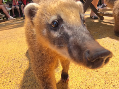
These coatimundis want the food from the tourists at the food court.
This coati wanted to eat Jason's camera.
What a hoover of a snout they have!
A double fall.
The crowds on the Argentina side of Iguazu Falls was extremely crowded in the mornings.
A lizard sunning on a plaque.
How do these trees stay put?
Karen on a walkway at Iguazu Falls.
Lots of water coming over the falls here has closed some of the walks and ripped off the main walkway over the water a few days after we were here.
The falls keep going and going and going......
Back in the Mendoza area, we went on a winery tour. This old copper kettle was on display in one of the wineries.
Wine is big science these days and these are all samples from different batches.
Llamas or alpacas in the water along the road at the end of the tour of the Uyuni Salt Flats.
This canyon was our last stop on the tour. A mini Grand Canyon and we were here in high winds, making the walk out on a promontory to take this photo a scary set of steps.
Karen standing on the edge of the rock walkway at the top of the canyon.
Looking down at the river in the canyon below. We're up here quite a ways and the wind was blowing rocks and gravel across the rock tops here.
The green lagoon on the Uyuni Salt Flats tour. This one is toxic and didn't have flamingoes in it.
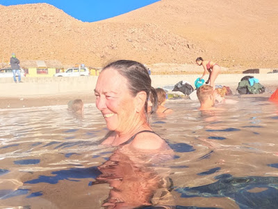
Jason and Karen in the hot pools we stopped at after the cold of the geysers in the morning. Nobody else in the tour wanted to get into the water. It was wonderful!
Karen in the hot springs on the Uyuni tour.
Karen walking out of the steam from the geysers and boiling mud pools.
Looking through the steam of the mud pools. The steam felt warm for a few seconds, but it was freezing temps here and the wet hands froze very quickly when we got back into the winds. Brrrrrr.
You could take a dangerous misstep if you tried walking in the steam here.
The red lagoon. There are hundreds of pink flamingoes out here in the lake.
The Toyota Land Cruisers lined up at one of the lagoons where we stopped to eat lunch.
Rock formations where we stopped for the Arbol de Piedra/Tree of Rock.
The Tree of Rock, a tourist attraction.
The 'tree' looks so different when you change the view.
This green plant grows only on the volcanic rocks at certain latitudes here. They are reputed to have fabulous medicinal qualities, but there isn't enough of it to make it viable.
A railway to Chile from Bolivia across the desert. It was a mining railroad that isn't used much anymore.
One of the beds in the salt hostel we stayed at on the tour. The bricks are all made of salt; in fact, just about everything in this building is made of salt.
Sunset over a mountain on the Uyuni Salt Flats.
A wet spot on the salt flats where a town is trying to build a new road out to where the salt is firm and dry. Then they won't have to drive all the way around the salt flat.
Karen on a tower of salt bricks at a new labyrinth in the middle of the salt flat.
Broken bricks of salt near a harvest site.
Karen and Jason fending off a giant dinosaur at Uyuni Salt Flat in Bolivia.
Karen waiting for others at our vehicle for the tour.
Our sticker on the window of the Salt Hotel, where we had our first tour lunch.
A rusted locomotive and train cars at the Train Cemetery outside of Uyuni in Bolivia.
A metal artist has a huge display of animals and figures across from the train cemetery.
YOLO parked on the beach of Fish Island, where we spent two nights in the middle of the Uyuni Salt Flats in Bolivia.
The pressure ridges on the salt flats were kind of pretty, I thought
A salt table and seats out on the salt flat off of Fish Island. You can see YOLO in the background on the beach.
Cacti on Fish Island.
Karen and YOLO on the Uyuni salt flats.
Karen next to a salt woman at the Salt Hotel.
Stickers cover all the windows of the Salt Hotel. Ours is in the top right hand corner.
The flags of nations at the salt hotel. The American flag was absent.
Karen at the Dakar salt statue near the Salt Hotel.
Some of the salt water bubbling up to the surface. You can understand why I was leery of driving on the salt flats when this water is only inches below the surface! But it was only in a few spots and most of the salt is dry below, too.
Moon Valley outside of La Paz. We were too early to get in so these are what we could see from outside the fence.
Looking down at La Paz, Bolivia from the Purple cable car.
A statue at the rest stop on Jason's bike ride on the Death Road outside of La Paz.
The pool where the bike tour group stopped for lunch.
Death Road biker at the edge of a drop off.
Jason on the edge of a cliff on the Death Road bike tour.
Death Road is pretty narrow and only suited for bikes and their support vehicles these days.
A bus moves along the cliffside of the Death Road.
Jason's biker group from the Death Road Bike Tour.
Quite the view of the road and scenery along it.
Bikers on the Death Road taking a break.
Jason on a point along the Death Road bike tour. Behind him is a drop off of many hundreds of feet!
Grilled trout we had with our fried guinea pig (cuy) in a border town.
A communication tower on one of the floating islands of Uros.
Each family and island maintain a boat that resembles a puma and has two hulls. They use them for tourist rides to make money these days, but families used to live on these boats.
The floating reed islands of Uros are in the Lake Titicaca.
The boat of our host's family. Yordy took us out to his island and gave us a tour and explained about the reed islands here.
Yordy's home on his family's floating island made of reeds in Uros, Bolivia. They need to add a new layer of reeds every couple of weeks and the low water level of the lake is making it harder to find the reeds they need.
Yordy's wife, Dina, displays the cloths she's sewn and hopes to sell. Each of them tells a traditional story in figures.
Yordy makes the crafts and toys to sell as souvenirs to earn money.
Jason and Karen in traditional Uros garb.
Yordy explains how they hunt birds on the lake. The gun is just a display one.
A black alpaca at Palccoyo, the colored mountain.
Karen at Palccoyo, the colored mountain in Peru. It was an overcast day so the colors are washed out and dull, but they were still gorgeous to see in person.
The same mountain as the cover photo of the Peru Lonely Planet guide for 2023.
The Stone Forest at the top of the hill at Palccoyo. Layers of rock stood on their sides and weathered for centuries.
















No comments:
Post a Comment